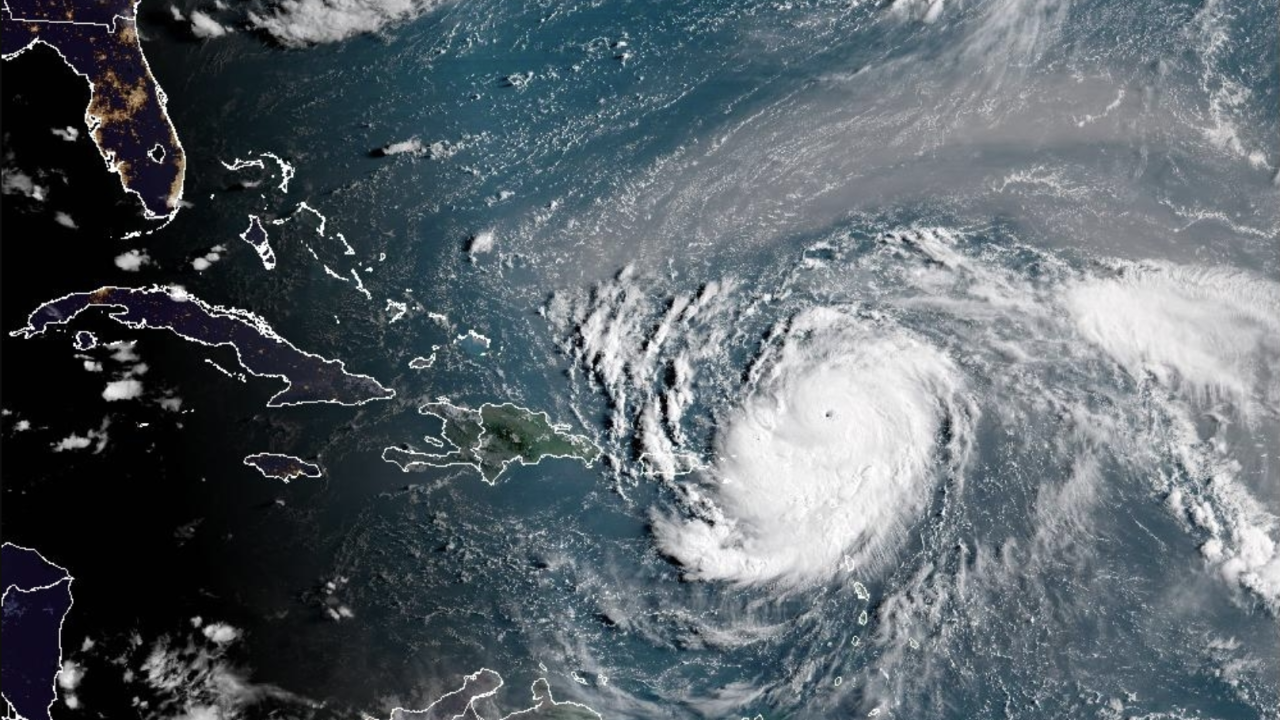
Hurricane Erin quickly strengthened from a tropical storm to a Category 5 storm in the Caribbean on Saturday, according to the National Hurricane Center.
The center of the compact storm was not predicted to make landfall, but as it grew larger, it threatened to unleash torrential rainfall.
Erin quickly developed into a “very powerful hurricane,” going from maximum sustained winds of 100 mph to 160 mph in just nine hours, according to Mike Brennen, director of the National Hurricane Center in Miami.
“We expect to see Erin peak here in intensity relatively soon,” Brennan stated during a briefing conducted online.
In just one day, Erin, the first Atlantic hurricane of 2025, intensified from a tropical storm to a Category 5 hurricane. Its maximum sustained winds more than doubled to 160 mph by late Saturday morning.
At around 11 a.m. on Saturday, the hurricane was 105 miles north of Anguilla and was traveling at 17 mph west. The center of the storm was expected to pass north of Puerto Rico and the Virgin Islands and stay at sea without making landfall.
Erin was near enough to have an impact on neighboring islands. St. Martin, St. Barts, and St. Maarten were under tropical storm watches. The Hurricane Center issued a warning that flash flooding, mudslides, and landslides could occur in some places due to heavy rainfall.
In the southeast Bahamas and the Turks and Caicos Islands, wind gusts of tropical storm force are probable.
Despite being small, with hurricane-force winds 30 miles out from its center, the Hurricane Center predicted that Erin will double or even triple in size over the next few days. This implies that even though the hurricane is expected to stay far offshore, it might produce strong rip currents off portions of the U.S. East Coast later this week.
Compared to much of the southern Atlantic, mid-Atlantic, and northern New England coasts, protruding U.S. coastal areas like Cape Cod, Massachusetts, Long Island, New York, and North Carolina’s Outer Banks are more likely to experience direct and possibly severe tropical storm or hurricane conditions, according to AccuWeather.
Scientists have connected climate change to the Atlantic Ocean’s hurricanes’ fast intensification. Ocean temperatures are rising as a result of the atmosphere retaining more water vapor due to global warming. Hurricanes can produce more rain and intensify faster due to the warmer oceans.
Rapidly intensifying storms make it more difficult for meteorologists to forecast and for government organizations to prepare for catastrophes. Additionally, Hurricane Erick, a Pacific storm that hit Oaxaca, Mexico, on June 19, intensified quickly, tripling in strength in less than a day.
RELATED STORY | NOAA predicts that storm activity will remain above normal for the remainder of hurricane season.
The Atlantic hurricane season, which begins on June 1 and ends on November 30, has five named storms, including Erin. The first to turn into a storm.
Hurricane season in 2025 is predicted to be exceptionally busy. Six to ten storms are predicted, three to five of which will become majors with maximum sustained winds of 110 mph (177 kph).
Forecasters issued a flood watch for the whole U.S. island from late Friday until Monday, prompting the U.S. government to send more than 200 staffers from the Federal Emergency Management Agency and other agencies to Puerto Rico as a precaution.
According to Ciary P. Rez Pea, the housing secretary for Puerto Rico, 367 shelters have undergone inspection and may be established if necessary.
Six seaports in Puerto Rico and two in the U.S. Virgin Islands are restricted to all arriving vessels unless they have prior authorization, the U.S. Coast Guard announced on Friday.
As they encouraged people to follow the cyclone, Bahamas officials said they had set up a few public shelters as a precaution.
Aarone Sargent, managing director of the Bahamas’ disaster risk management authority, stated that “these storms are very volatile and can make sudden shifts in movement.”