The national weather service has issued a flood watch for Boone, Kenton and Campbell Counties, as well several counties in Ohio and Indiana. The watch is in effect from 1 p.m. Sunday until Monday morning.
The stories all of NKY will be talking about, delivered to your inbox each weekday morning.
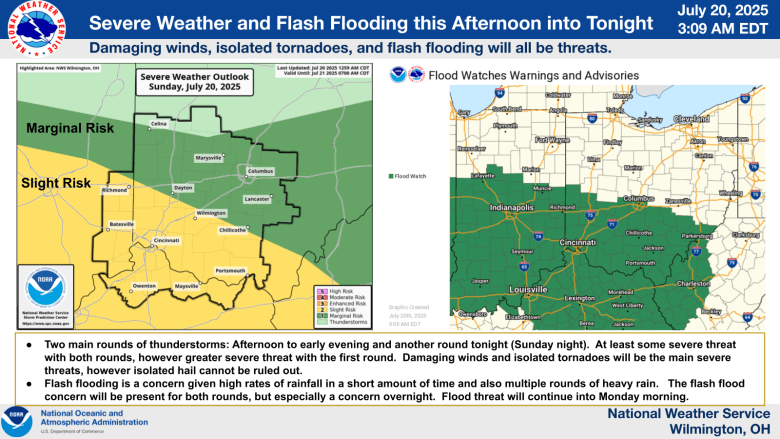
“Severe weather will be possible this afternoon [Sunday] into tonight with damaging winds, isolated tornadoes and flash flooding,”
according to the National Weather Service.
The service recommends having multiple ways to receive weather alerts on hand during the watch.
Similar graphic to earlier but new messages!
We’re getting more concerned about flooding for the areas within and near the pink/ southerly circle. Storms are setting up in a way where repeated rounds of rainfall will occur!
pic.twitter.com/hznYPIlyMD
— NWS Wilmington OH (@NWSILN)
July 20, 2025
You can view the precipitation radar below or at the
National Weather Service’s dedicated radar page
.
Stay up to date with announcements and warnings at
weather.gov
or at the
National Weather Service’s X page
.
Refresh the page for up-to-date radar results.
Liked this story? Help make the next one possible.
Independent local news doesn’t happen without community support. Your monthly donation helps us keep covering the people, issues, and places that make Northern Kentucky what it is.
When you give, you’re not just supporting one story — you’re investing in all the ones still to come.
SUPPORT LOCAL NEWS